
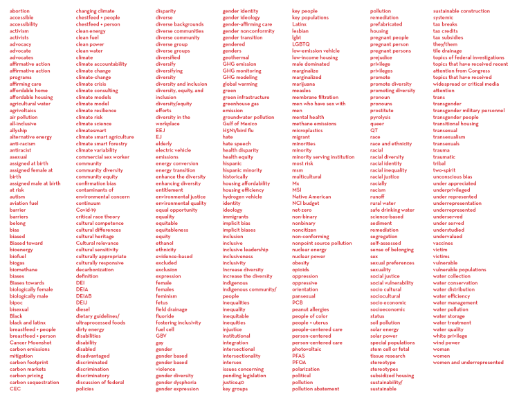
This is one of the terms you can’t say in the Trump Regime. See a comprehensive list at the Forbidden Words Project.
forbidden word: GHG monitoring
GHG monitoring
from climate.gov
This website is an ARCHIVED version of NOAA Climate.gov as of June 25, 2025.
Content is not being updated or maintained, and some links may no longer work.
To access current NOAA climate information resources, please visit www.noaa.gov/climate
GHG Monitoring Capabilities

NOAA collects data via aircraft, mobile laboratories, ships, monitoring stations, and other measurements and models. The data is used to research GHG sources, quantify emissions by region and sector, and improve emission inventories for better decision-making.
Download the State of the Science Fact Sheet PDF
NOAA-Sponsored GHG Emission Trackers & Tools
- NOAA Global Monitoring Laboratory’s Emission Tracker for potent GHGs
Provides measurement-based estimates of emissions of greenhouse gases and other atmospheric trace gases that impact climate, stratospheric ozone, and air quality over the contiguous United States. - CarbonTracker CO2
CarbonTracker is a carbon dioxide (CO2) measurement and modeling system that tracks global sources (emissions to the atmosphere) and sinks (removal from the atmosphere) of carbon dioxide. - CarbonTracker for Methane (CH4)
CarbonTracker for methane (CH4) is a measurement and modeling system that provides global-scale estimates of methane emissions that come from microorganisms, fossil fuels, and organic matter. - CarbonTracker-Lagrange (CT-L)
CarbonTracker-Lagrange (CT-L) is a new regional modeling framework for estimating North American greenhouse gas emissions and uptake fluxes. - Greenhouse Gas and Air Pollutants Emissions System (GRA2PES)
NOAA and NIST collaboratively developed a new capability to measure and model U.S. emissions of greenhouse gases and hazardous air pollutants. The main goals are to support research and development of GHG emission reduction plans and strategies. - Urban GHG Emissions Measurement and Monitoring System (Urban-GEMMS)
An operational capability to measure and model U.S. emissions of greenhouse gases. This is prototype of the Integrated Urban U.S. Greenhouse Gas Measurement, Monitoring, and Information System. - U.S. GHG Center
A new web portal designed to make it easier to find data, information, and computer models from multiple agencies in one location. The site offers a curated catalog of GHG datasets and analysis tools. - Surface Ocean CO2 Atlas (SOCAT)
Publicly available surface water data from the global oceans, including the Arctic, and the coastal seas. - Global Ocean Data Analysis Project (GLODAP)
A synthesis effort providing regular compilations of surface-to-bottom ocean biogeochemical bottle data, with an emphasis on seawater inorganic carbon chemistry and related variables determined through chemical analysis of seawater samples.

Greenhouse gas measuring and monitoring platforms at NOAA.
NOAA is a world-leading authority on measuring and monitoring greenhouse gases. For more than 50 years, NOAA has designed, deployed and maintained observational platforms that collect measurements on global, regional, and local scales. We collect measurements every day from a wide array of observing platforms (top left image) to advance scientific understanding of greenhouse gases’ sources and sinks (where they come from and where they end up).
Society’s ability to understand and address the root causes of global warming, and associated climatic changes, depends on the scientific evidence gathered by NOAA’s observing platforms. Likewise, NOAA GHG data are essential to understanding whether, where, and to what extent emission-reduction and carbon dioxide removal strategies are effective, today and into the future.
Learn more at the NOAA Global Monitoring Laboratory
Related articles
- NOAA and United Airlines partner to measure greenhouse gases, pollutants with high-tech flight instruments
- ARL Plays Key Role in U.S. Greenhouse Gas Measurement, Monitoring, and Information System
- Does it matter how much the United States reduces its carbon dioxide emissions if China doesn’t do the same?
- NOAA’s observations help EPA track emissions of a family of greenhouse gases

NOAA’s Global Monitoring Lab operates several carbon cycle monitoring programs. Icons on this global show where and what types of measurements are collected around the world.
NOAA Contributors to GHG Monitoring
- Air Resources Laboratory (ARL)
ARL collects measurements of GHGs from aircraft, mobile, and surface platforms, and uses a computer model (HYSPLIT) to track GHGs in the atmosphere. ARL research improves estimates of GHG fluxes between air and land, from local to global scales. - Atlantic Oceanographic and Marine Laboratory (AOML)
AOML measures air-sea carbon dioxide fluxes using instruments on ships, buoys, and uncrewed surface vehicles, and conducts surface-to-seafloor surveys from ships to monitor CO2 in the ocean. These data are made publicly available via the Surface Ocean CO2 Atlas (SOCAT) and the Global Carbon Budget annual report. - Chemical Sciences Laboratory (CSL)
CSL conducts research at the intersection of climate and air quality utilizing airborne, ground-based, and satellite observations of GHGs and co-emitted air pollutants and chemical transport models to map atmospheric concentrations, emissions sources and sinks, and support the development of NOAA’s weather-chemistry models. - Climate Program Office (CPO)
Atmospheric Chemistry, Carbon Cycle, and Climate (AC4) program supports NOAA-led initiatives like CarbonTracker and field campaigns, coordinating GHG efforts across NOAA. It also supports the external research community with competitive grants through annual solicitations. - Geophysical Fluid Dynamics Laboratory (GFDL)
GFDL develops and applies numerical models to advance understanding of historical and future drivers of changes in greenhouse gases and their influence on the Earth system. - Global Monitoring Laboratory (GML)
GML maintains long-term monitoring networks with a continuous record of GHGs for trend studies and process understanding. GML also provides CarbonTracker—a modeling system that shows annual fluxes of carbon dioxide and methane on a local-to-global scale. - Global Ocean Monitoring & Observing Program (GOMO)
GOMO supports half of the world’s ocean observing research, including carbon fluxes between ocean and atmosphere. - National Centers for Environmental Information (NCEI)
NCEI develops a repository of U.S. and global environmental data, products, and monitoring and assessment services that collectively characterize Earth and beyond. - Ocean Acidification Program (OAP)
OAP provides support for NOAA’s ocean acidification observing network. - Pacific Marine Environmental Laboratory (PMEL)
PMEL measures air-sea carbon dioxide fluxes using instruments on ships, buoys, and uncrewed surface vehicles, and conducts surface-to-seafloor surveys from ships to monitor CO2 in the ocean. These data are made publicly available via the Surface Ocean CO2 Atlas (SOCAT) and the Global Carbon Budget annual report.

This map shows the locations where measurements of carbon dioxide at the ocean’s surface have been made around the world for at least a decade. Red lines show the tracks of NOAA ships and uncrewed surface vehicles; gray lines show non-NOAA watercraft. Red squares show locations of NOAA’s moored buoys; gray squares show non-NOAA buoys. Credit: NOAA GML
NOAA-Sponsored Research Campaigns & Networks
- GO-SHIP
International ship-based cruise project that monitors changes in the ocean basins from coast to coast and full depth to help visualize the effects of climate change on the ocean. - Ocean Acidification Cruises
Coastal and ocean acidification research cruises along the U.S.’s major coastlines help us track long-term ocean change and evaluate our monitoring network of buoys, gliders, and other tools. - Ocean Carbon Network
Provides long-term observations of carbon from the sea surface to the sea floor. - Surface Ocean CO2 Reference Observing Network (SOCONET)
SOCONET provides high-quality global surface ocean CO2 data. - AIrborne and Remote sensing Methane and Air Pollutant Surveys (AiRMAPS)
AiRMAPS is a series of studies led by NOAA Oceanic and Atmospheric Research (OAR) and NOAA National Environmental Satellite, Data, and Information Service (NESDIS) to investigate greenhouse gas and air pollutant emissions and impacts. - Biogeochemical-Argo Program (BGC-Argo)
BGC-Argo uses robotic ocean floats to collect unparalleled observations across the open Gulf of Mexico, a previously under-observed region. - Global Greenhouse Gas Reference Network
This measures the atmospheric distribution and trends of carbon dioxide, methane, nitrous oxide, and carbon monoxide.
Recommended Reading
- Measurements at 4 NOAA Atmospheric Baseline Observatories and multiple tall towers in the United States
- Air samples collected by volunteers at more than 50 sites around the world
- Air samples collected regularly from small aircraft mostly in North America
- Vertical profiles using balloons and the Aircore sampling system
- Making observations to understand carbon system dynamics in the ocean
- Download the State of the Science Fact Sheet: Greenhouse Gases and Climate PDF
from — GHG monitoring capabilities. (n.d.). NOAA Climate.gov. Retrieved April 15, 2026
~ ~ ~
Greenhouse Gas Monitoring
-
Greenhouse gas monitoring is the direct measurement of greenhouse gas emissions and levels. There are several different methods of measuring carbon dioxide concentrations in the atmosphere, including infrared analyzing and manometry. Methane and nitrous oxide are measured by other instruments. Greenhouse gases are measured from space such as by the Orbiting Carbon Observatory and networks of ground stations such as the Integrated Carbon Observation System.
Methodology
Carbon dioxide monitoring
Manometry
Manometry is a key measurement tool for atmospheric carbon dioxide by first measuring the volume, temperature, and pressure of a particular amount of dry air. The air sample is dried by passing it through multiple dry ice traps and then collecting it in a five-liter vessel. The temperature is taken via a thermometer and pressure is calculated using manometry. Then, liquid nitrogen is added, causing the carbon dioxide to condense and become measurable by volume.[1] The ideal gas law is accurate to 0.3% in these pressure conditions.
Infrared gas analyzer
Infrared analyzers were used at Mauna Loa Observatory and at Scripps Institution of Oceanography between 1958 and 2006. IR analyzers operate by pumping an unknown sample of dry air through a 40 cm long cell. A reference cell contains dry carbon dioxide-free air.[1] A glowing nichrome filament radiates broadband IR radiation which splits into two beams and passes through the gas cells. Carbon dioxide absorbs some of the radiation, allowing more radiation that passes through the reference cell to reach the detector than radiation passing through the sample cell. Data is collected on a strip chart recorder. The concentration of carbon dioxide in the sample is quantified by calibrating with a standard gas of known carbon dioxide content.[1]
Titrimetry
Titrimetry is another method of measuring atmospheric carbon dioxide that was first used by a Scandinavian group at 15 different ground stations. They began passing a 100.0 mL air sample through a solution of barium hydroxide containing cresolphthalein indicator.[1]
Methane gas monitoring
Differential absorption lidar
Range-resolved infrared differential absorption lidar (DIAL) is a means of measuring methane emissions from various sources, including active and closed landfill sites.[2] The DIAL takes vertical scans above methane sources and then spatially separates the scans to accurately measure the methane emissions from individual sources. Measuring methane emissions is a crucial aspect of climate change research, as methane is among the most impactful gaseous hydrocarbon species.[2]
Nitrous oxide monitoring
Atmospheric Chemistry Experiment‐Fourier Transform Spectrometer (ACE-FTS)
Nitrous oxide is one of the most prominent anthropogenic ozone-depleting gases in the atmosphere.[3] It is released into the atmosphere primarily through natural sources such as soil and rock, as well as anthropogenic process like farming. Atmospheric nitrous oxide is also created in the atmosphere as a product of a reaction between nitrogen and electronically excited ozone in the lower thermosphere.
The Atmospheric Chemistry Experiment‐Fourier Transform Spectrometer (ACE-FTS) is a tool used for measuring nitrous oxide concentrations in the upper to lower troposphere. This instrument, which is attached to the Canadian satellite SCISAT, has shown that nitrous oxide is present throughout the entire atmosphere during all seasons, primarily due to energetic particle precipitation.[3] Measurements taken by the instrument show that different reactions create nitrous oxide in the lower thermosphere than in the mid to upper mesosphere. The ACE-FTS is a crucial resource in predicting future ozone depletion in the upper stratosphere by comparing the different ways in which nitrous oxide is released into the atmosphere.[3]
Satellite monitoring
Orbiting Carbon Observatory (OCO, OCO-2, OCO-3)
The Orbiting Carbon Observatory (OCO) was first launched in February 2009 but was lost due to launch failure.[4] The Satellite was launched again in 2014, this time called the Orbiting Carbon Observatory-2, with an estimated lifespan of about two years. The apparatus uses spectrometers to take 24 carbon dioxide concentration measurements per second of Earth’s atmosphere.[5] The measurements taken by OCO-2 can be used for global atmospheric models and will allow scientists to locate carbon sources when its data is paired with wind patterns. The Orbiting Carbon Observatory-3 operates from the International Space Station (ISS).[4]
Greenhouse Gases Observing Satellite (GOSat)
Satellite observations provides accurate readings of carbon dioxide and methane gas concentrations for short-term and long-term purposes in order to detect changes over time.[6] The goals of this satellite, released in January 2009, is to monitor both carbon dioxide and methane gas in the atmosphere, and to identify their sources.[6] GOSat is a project of three main entities: the Japan Aerospace Exploration Agency (JAXA), the Ministry of the Environment (MOE), and the National Institute for Environmental Studies (NIES).[6]
Ground stations
Integrated Carbon Observation System (ICOS)
The Integrated Carbon Observation System was established in October 2015 in Helsinki, Finland as a European Research Infrastructure Consortium (ERIC).[7] The main task of ICOS is to establish an Integrated Carbon Observation System Research Infrastructure (ICOS RI) that facilitates research on greenhouse gas emissions, sinks, and their causes. The ICOS ERIC strives to link its own research with other greenhouse gas emissions research to produce coherent data products and to promote education and innovation.[7]
Integrated Monitoring
Among the common methods for measuring emissions are top-down approaches, which rely on atmospheric measurements, and bottom-up methods, which utilize ground-based sensors. Each of these methods has its advantages and limitations. An integrated real-time monitoring system can address these challenges by detecting leaks in near real-time and providing actionable insights for stakeholders to enable effective mitigation strategies. However, implementing such a system presents significant challenges and difficulties that must be carefully considered.[8] A 2023 review by Allen et al. found that, despite advances in remote sensing and ground-based measurement, major gaps remain in the spatial and temporal coverage, methodological consistency, and transparency of greenhouse-gas emissions data, limiting the reliability of emissions reporting and verification of national climate commitments.[9]
See also
- Carbon accounting
- Greenhouse gas inventory
- Infrared gas analyzer
- Mauna Loa Observatory
- Keeling Curve
- Climate Trace Rapid and public GHG monitoring
from — Wikipedia contributors. (2025, November 2). Greenhouse gas monitoring. Wikipedia. Retrieved April 15, 2026
April 15, 2026
Salem, MA
See the complete list at the Forbidden Words Project.
image: in the grape arbor © holly troy 2026
The White House has said it did not create a banned words list but has instead left it to federal agencies to interpret how to comply with executive orders that solely recognize male and female sex or eliminate diversity, equity, and inclusion programs. Nonetheless, some departments have added terms that seem to have nothing at all to do with those executive orders.
from — Connelly, E. A. (2025, December 22). Federal Government’s Growing Banned Words List Is Chilling Act of Censorship. PEN America.
Discover more from holly troy ~ sacred folly
Subscribe to get the latest posts sent to your email.

Every government / must monitor greenhouse gas / emissions or die
LikeLike